Municipality Introduction
Chapter - 2
2.1 Geographic Location
Chaudandigadhi Municipality, located in Udayapur district, one of the 7 Inner Terai districts in Nepal, has a total area of 283.78 sq. km. Geographically, this municipality extends from 26 degrees 41 minutes 26 seconds North latitude to 26 degrees 54 minutes 27 seconds North latitude and from 86 degrees 46 minutes 07 seconds East longitude to 86 degrees 59 minutes 32 seconds East longitude. The municipality is bordered by Belka Municipality in the East, Triyuga Municipality in the West, Khotang and Bhojpur districts in the North, and Saptari district in the South. As most of the land here falls under Inner Terai, there is a dominance of very fertile soil mixed with sand and silt. Tropical and sub-tropical climate is found here, and it is cold in the months of Poush and Magh, while it is hot in the months of Baishakh, Jestha, and Ashad.
2.2 Historical Background and Naming
The current Chaudandigadhi Municipality was named after the Chaudandi state and the historic fort located in Chaudandi, which was formed when the then Sen dynasty kings divided the state into pieces to distribute among brothers.
Political and Administrative Structure
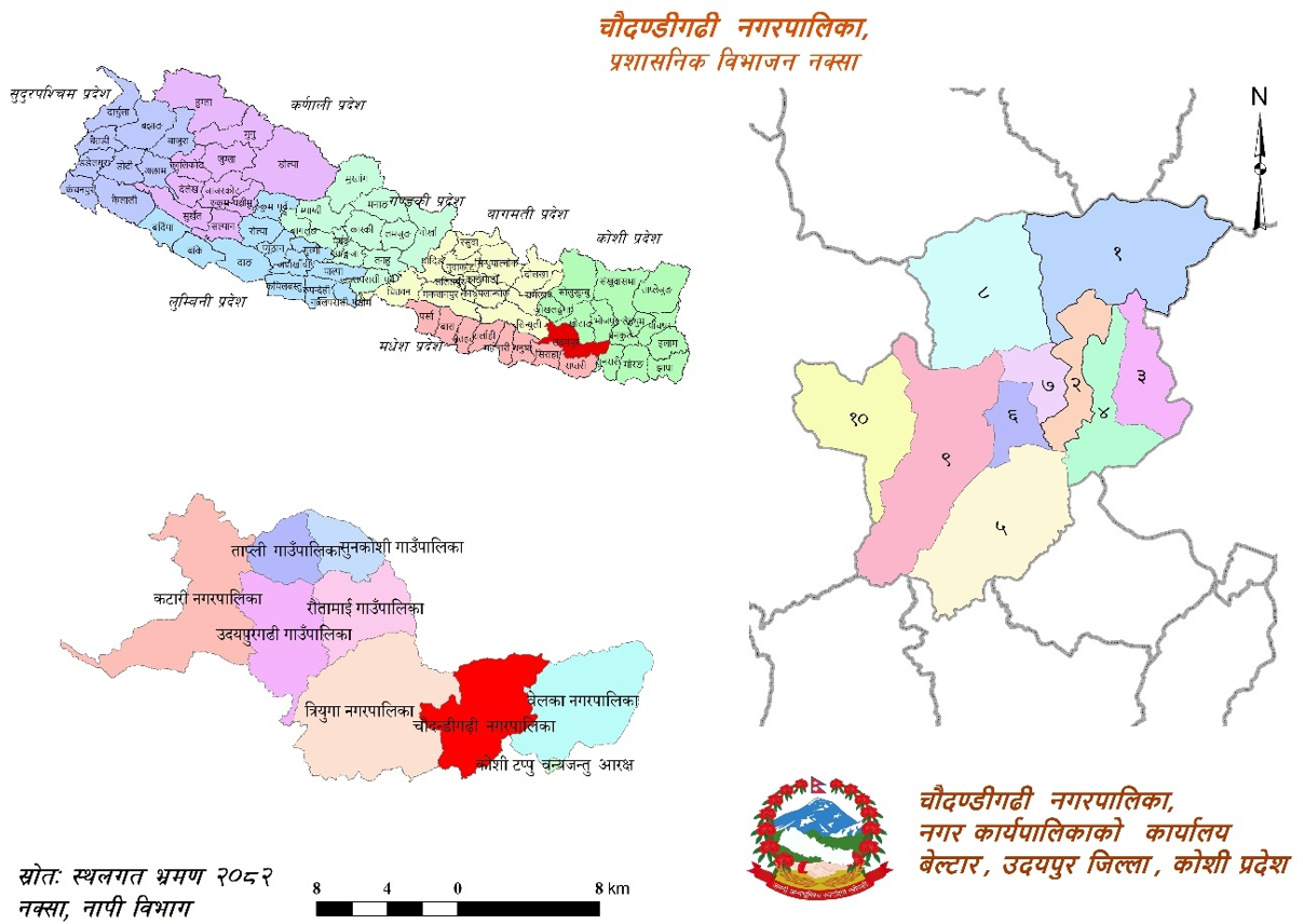
Map No. 1: Administrative Division Map
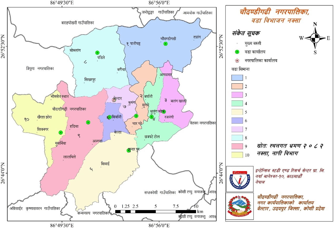
Map No. 2: Municipality Ward Division Map
Beltar Basaha Municipality, formed by merging the former Beltar and Basaha VDCs, was established by incorporating Chaudandi, Siddhipur, Hadiya, and Sundarpur VDCs. Currently, there are 10 wards in this municipality. The detailed description is presented in the table below.
Table No. 1: Political and Administrative Structure
| Ward No. | Included VDC/Municipality | Ward No. | Area (sq km) |
|---|---|---|---|
| 1 | Chaudandi (1-9) | 3,882 | 47.94 |
| 2 | Beltar Basaha (5,6) | 4,059 | 13.74 |
| 3 | Beltar Basaha (9,10) | 3,871 | 17.02 |
| 4 | Beltar Basaha (7,8,11) | 6,235 | 19.76 |
| 5 | Sundarpur (1-9) | 5,673 | 43.64 |
| 6 | Beltar Basaha (2,3) | 4,516 | 9.01 |
| 7 | Beltar Basaha (1,4) | 5,237 | 9.37 |
| 8 | Siddhipur (1-9) | 3,770 | 44.09 |
| 9 | Hadiya (2-6) | 6,753 | 49.43 |
| 10 | Hadiya (1,7-9) | 4,578 | 29.76 |
| Total | 48,574 | 283.78 | |
Source: Field-based data based on GIS
2.4 Topography
When preparing the description of the physical condition, it is mandatory to mention the terrain conditions here. Although Nepal is small in terms of area, it is considered rich in the world in terms of terrain diversity. Especially during the geological process, when the Mahalangur mountain range was formed recently, the Tethys Sea existing between the Tibetan block and the Indian subcontinent ceased to exist due to the collision between them, and the land surface of the entire country was formed by the combination of the High Himalayas, the Middle Mahabharat mountain range, the lower Chure mountain range, and the Terai region which is a part of the vast Ganges plain spread in the southernmost part. It is found that there is a dominance of one or another type of terrain among the objective characteristics of this terrain in the rural municipalities or municipalities of Nepal. The terrain structure plays a crucial role in development and construction. Basic aspects such as slope, aspect, elevation, land cover, and soil texture fall under the terrain description.
a) Soil Texture
The geological structure of the municipality was formed during the formation of the Mahabharat mountain range, which originated from the collision between the Indian Plate and the Tibetan Plate. It remains as a part of the vast Ganges River. However, looking at the terrain profile, diversity is found in soil and rocks. The reasons for this are the natural phenomena constantly occurring on the land surface such as weather and seasonal changes, soil erosion, atmospheric pressure effects, rainfall, dew, earthquakes, climate change, normal storms, etc. As it is located in the Inner Terai and some parts in the hilly region, clayey soil is found in the hilly areas and sandy soil in the flat areas of the municipality. Thus, the amount of organic matter is slightly higher in areas where continuous cultivation is being done, while it is gradually decreasing in barren areas.
b) Description of Slope
Studying the land of Chaudandigadhi Municipality based on land structure, ecological system, and landslides trends, the classification of land is placed in the order of degrading usability and intensity. In other words, the trend of landslide or soil erosion varies according to land structure. In that order, soil condition and slope have been analyzed based on physical characteristics of measures to strengthen land stability. Looking at land classification based on elements like land structure, ecological system, and landslides in the municipality, a slope from a minimum of 0 degrees to a maximum of 63 degrees is seen in the municipality's land. Which is mentioned in the map.
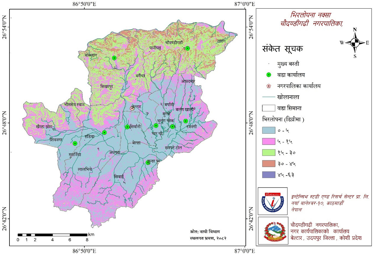
Map No. 3: Municipality Slope Distribution Map
a) Slope 0°– 5° (Sufficient soil depth, suitable for farming by making terraces with good water drainage)
In such land, the soil depth is sufficient, and water easily drains on the surface and even in semi-underground conditions. Terraces should be made on such land for monsoon farming. Control measures should be adopted so that surface water flow and semi-underground water drainage do not cause soil erosion. Special attention should be given to conserve land of this class because new gullies are formed from rainwater due to physical properties of soil and land slope, and these gullies eventually widen, increasing the trend of soil erosion.
b) Slope 5º - 30º (Soil depth 50–100 cm, farming possible only by making terraces with good water drainage)
Land with 50–300 slope, good water drainage, and soil layer depth from 50 cm to 100 cm falls in this class. Trends of soil erosion like landslides and land subsidence appear normally in land of this class. Therefore, if the land is not managed properly, such trends will increase further. This land is not that easy for forests and vegetation. Since soil erosion increases due to the movement of cattle, it is not right to encourage grazing development on this type of land. But, if cattle are grazed by confining them to certain places in turn, it can also help in the productivity of the land. It is mandatory to make terraces to prevent soil erosion for monsoon farming on this type of land. Traditional and medium-level technology of farming has to be adopted in this. When farming on land with this type of slope, the mixture of management skills with physical properties of soil plays a main role. If irrigation has been used regularly from before, soil erosion problems do not occur during irrigation, but if a new irrigation system is to be started, precautions should be taken initially. If there is sudden excessive irrigation, the trend of soil erosion can start immediately. Traditional methods or modern methods can be used for farming on land of this class. Due to the rain during monsoon, grazing and vegetation also benefit significantly. Paddy farming can be done on such land. Irrigation facility is available. Paddy crops can be planted even if the soil is granular. If there is irrigation, winter and monsoon crops can also be planted.
c) Slope 30º - 40º (Soil depth only 20 cm, easy water drainage, and land slope more than 300 (1 m in 1.7 m), suitable for producing timber firewood)
Land with soil layer depth of only 20 cm, easy water drainage, and land slope more than 300 (1 m in 1.7 m) falls in this class. It does not seem beneficial to farm by making terraces on land with such high slope. There is a high possibility of quick formation of gullies or damage by floods from rainwater on this type of land. It seems suitable to plant vegetation on this type of land. It is appropriate to increase the production of forest products for timber and fuel here. The trend of landslides or damage from floods are common symptoms of this type of land. Forests can be developed in such areas to produce fuel, animal feed, and timber. Even if deforestation has occurred, plants can either be regrown or afforestation can be done in such areas. The practice of grazing cattle on lands falling in this class should be strictly controlled. Even if it is to be used for fuel, animals, feed, and grazing, annual use should not be such that it jeopardizes future productivity. Road expansion and safe planning should be done for methods, location, and access to use such forest products in this type of area. Such land is not suitable for farming.
d) Slope >40º (Soil depth less than 20 cm, recurring soil erosion, low possibility of regeneration)
Land that is very steep, or has soil layer less than 20 cm even if moderately steep, or damaged by monsoon rain regardless of slope, and where many gullies are created falls in this class. This type of land should be kept green by planting grass or plants because, as mentioned above, on one hand, the trend of soil erosion is rapid in such land, and on the other hand, it is impossible to reclaim an area where landslides have once occurred. Since soil temperature remains low in high areas and due to slope, soil flows easily. The details of the slope of Chaudandigadhi Municipality are mentioned in the table below.
Table No. 2: Details of Municipality Slope
| Slope (degrees) | Area (sq km) | Area (%) |
|---|---|---|
| 0 degree to 5 degree | 119.53 | 42.12 |
| 5 degree to 15 degree | 82.40 | 29.04 |
| 15 degree to 30 degree | 65.82 | 23.19 |
| 30 degree to 45 degree | 15.37 | 5.42 |
| 45 degree to 63 degree | 0.65 | 0.23 |
| Total | 283.78 | 100.00 |
Source: Field-based data based on GIS
About 42.12 percent of the land area here is in the condition of slope from 0 degrees to 5 degrees, 29.04 percent from 5 degrees to 15 degrees, 23.19 percent from 15 degrees to 30 degrees, 5.42 percent from 30 degrees to 45 degrees, and 0.23 percent from 45 degrees to 63 degrees. This means it is very easy to do farming on the land here. The municipality holds the capacity to become a food storehouse through farming. If the land here can be utilized correctly, Chaudandigadhi Municipality, rich in natural resources, holds the capacity to revolutionize development.
c) Description of Land Aspect
Land slope and aspect are generally complementary to each other. That is, when slope is uneven, there is unevenness in aspect too. Although there is no unevenness in aspect in flat areas, the municipality has the following aspect description.
Table No. 3: Description of Land Aspect
| Aspect | Area (sq km) | Area (%) |
|---|---|---|
| North Aspect | 38.63 | 13.61 |
| North-East Aspect | 32.81 | 11.56 |
| East Aspect | 31.84 | 11.22 |
| South-East Aspect | 37.97 | 13.38 |
| South Aspect | 39.43 | 13.90 |
| South-West Aspect | 35.97 | 12.67 |
| West Aspect | 32.25 | 11.36 |
| North-West Aspect | 34.89 | 12.29 |
| Total | 283.79 | 100.00 |
Source: Based on GIS Data
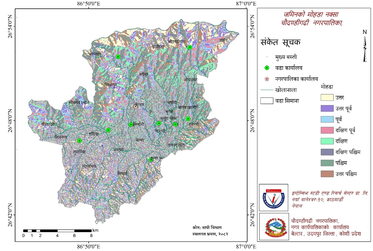
Map No. 4: Municipality Aspect Map
2.5 Natural Heritage
The main basis for the development of every area is the natural resources available there. Natural resources include locally available land, forests, vegetation, wildlife, herbs, mines and minerals, rivers, streams, lakes, mountains, waterfalls, watershed areas, wetlands, parks, reserves and protected areas etc. We can become prosperous only if we can make sustainable and judicious use of these natural resources.
2.6 Cultural Excellence
Human customs, language, behavior, and lifestyle are intangibly guided by certain traditions. To conduct daily behaviors, people are bound in the form of family and society. Marriage and tradition establish kinship relations, creating families. Birth, death, marriage, food habits, attire, festivals, language, lifestyle, etc., all fall within cultural characteristics. These dimensions of civilization and culture are the main aspects of human identity. Cultural activities help people live a refined life. It makes society organized and dynamic.
According to the National Census 2078 (2021 AD), there are 37,012 or 69 percent Hindu followers residing in the municipality. Similarly, 10,450 or 19.5 percent people follow Kirat religion, 4,143 or 7.7 percent follow Buddhism, and 1,477 or 2.8 percent follow Christianity.
Followers residing here celebrate festivals including Bada Dashain, Tihar, Ram Navami, Maha Shivaratri, Hartalika, Shree Panchami, Shree Krishna Janmashtami, Holi, Chaite Dashain, Saune-Maghe Sankranti, Matatirtha Aunsi, Akshaya Tritiya, Harishayani-Haribodhini Ekadashi, Nag Panchami, Raksha Bandhan (Janai Purnima), Kushe Aunsi, Bala Chaturdashi, Kojagrat Purnima, Shree Swasthani Purnima, New Year, Sorha Shraddha, Ubhauli (Baishakh Purnima) and Udhauli (Mangsire Purnima) Sakela festival, Buddha Jayanti, Bhume (Bhumya) festival, Christmas, and Lhosar.
People of various castes, religious sects, and attire reside in this municipality. All castes and sects have their own religion, culture, and customs. In this municipality, where there is a majority of Chhetri and Rai communities, during festivals, women wear Chhitko Gunyu, Chaubandi Choli, Rato Ghaleki and Yellow Patuka reflecting their culture, while men wear Bhoto and Half-coat, Kachhad below the waist, Topi on the head, and Galbandi. However, in modern times, youths of all castes prefer wearing pants, shirts, t-shirts, saree-blouse, and kurta-salwar.
2.7 Development Opportunities
Every place has its own characteristics. Some places have abundant forest areas. Some places have sufficient water resources, while some places are dry areas. Therefore, one can prosper by commercializing agriculture in arable areas, while local levels with abundant forest areas can be made prosperous through sustainable forest management. Based on available resources and means, the municipality's potential can be highlighted. Of the total area, 29.70 percent is cultivable land here. Prosperity can be achieved here through scientific agricultural systems.
Sustainable forest management refers to caring for and maintaining forests just like crops. Within the municipality area, there are potential areas for the development of traditional and modern agriculture, herbs, tourism, animal husbandry, and small and medium industries under possibilities and opportunities. Also, there is ample opportunity to develop it as a tourist area by constructing parks, gardens, and religious heritage sites in various places of the municipality.
There are abundant possibilities to increase production of food grains as well as other cash crops, vegetables, fruits, spices, herbs, and livestock products on the cultivable land in the municipality. Due to the lack of modern agricultural technology, fertilizers, and tools, as well as their high cost, their usage has decreased, and agricultural production has not increased as required. There are ample possibilities to improve the economic situation by increasing agricultural and livestock production through awareness, skill and commercialization, modernization, technology transfer, and simplifying the availability of necessary technology, fertilizers, credit, and seeds.
Due to the lack of modern agricultural systems in the fertile land here, the cultivable land has not been fully utilized, and on the other hand, the soil fertility is gradually depleting, leading to a decline in production and productivity. If haphazard settlement development can be managed, old traditional irrigation canals repaired to increase soil fertility, and work done according to the concept of sustainable development, this municipality can be developed as a livable place for future generations.
As there is ample potential for dairy production and poultry farming in the rural areas of the municipality, if this business can be expanded and transportation services can be extended to their reach in an accessible manner, milk chilling centers, collection centers/cold stores for agricultural products, meat-related industries, etc., can be developed in various places. Through this, there seems to be ample possibility to increase the overall income of the municipality by creating employment.
If the natural resources and means available in this municipality can be managed and used properly by adopting environment-friendly technology, it seems that the sector can create necessary employment at the local level in many rural areas and bring sustainability to local resource mobilization. Since there are some streams and ponds for commercial fish farming in the municipality area, and if ponds and artificial lakes are constructed in more potential places and fish farming business suitable for the climate of this area is done, employment opportunities will easily increase, and there is a possibility that the fish of the municipality itself will take over the market.
If the community forest user groups of the municipality are organized and institutionalized to promote and market non-timber products such as honey production in addition to herb farming in the forest area, it seems that it will provide further support for the economic progress of that sector.
As unemployment is increasing in the country and there are not enough employment opportunities in the government and non-government sectors, attraction towards foreign employment seems to have increased. If arrangements are made to create employment at the local level by providing skill-based training to the youth of this municipality, there seems to be a possibility of making a significant contribution to the economic development of the municipality.
By operating homestays in necessary places in this municipality, which carries abundant tourism potential, tourists visiting various places in Sindhuli and Udayapur districts can be attracted. In addition to this, various potential measures for the development of Chaudandigadhi Municipality can be mentioned as follows.
Agricultural production can be significantly increased if commercial farming can be done by irrigating water from underground water sources and streams within the municipality area through modern canals.
If local earthen roads can be upgraded and blacktopped, local residents can take full advantage, and the standard of living and the overall beauty of the municipality can increase.
Since there are various historical, religious, and cultural places in this area, there is ample potential for tourism development.
Since government, non-government, and private organizations are active in this area, they seem to be partners in the development of the municipality.
In the context of the increasing number of consumers in the municipality area, there seems to be a possibility of the development of industry, trade, and commerce.
2.8 Domestic Production
Gross Domestic Product (GDP) is a measure that reflects the overall economy of a country. It refers to the sum of the final transaction value of goods and services within a country or place in a certain period. It includes all private and public consumption, government spending, investment, inventory, expenses incurred during construction, and expenses and income from imports and exports. In Nepal, it seems calculated annually. According to Trading Economics, in 2024, Nepal's GDP is around 62 trillion 7 billion, with a per capita income of 1517 (one thousand five hundred seventeen) US dollars.
2.9 Human Development Index
According to the 2025 report of the United Nations Development Programme (UNDP), Nepal's Human Development Index is 0.622, ranking it 145th out of 193 countries in the world. This index of Nepal is lower than the average of 0.636 for countries with medium human development index. In 1990, this index for Nepal was 0.378.